| Last update
Fri, 15 Jan 2021 10am
![]()
![]()
| Last update
Fri, 15 Jan 2021 10am
![]()
![]()
TURNING THE WORLD SAFER
The environmental and infrastructural monitoring services offered by DIAN are differentiated based on the spatial extension and the kinematic characteristics of the natural phenomenon to be monitored.
Within the large scale environmental monitoring, based on SAR data acquired by satellite, we offer two services, as shown in Table 1. The main differences are:
| Offered service | Landslides | Subsidence and volcanoes | Tectonic and earthquakes | Infrastructures | Characteristics of the phenomenon to monitor |
|---|---|---|---|---|---|
| Historical Analysis | X | X | X | X | Slow phenomenon started and concluded in the past, or started in the past and still in development |
| Regular Monitoring | X | X | X | X | Slow phenomenon in the development phase |
Table 1 - Services offered for large scale environmental monitoring
A brief description of the supply process for the various large scale environmental monitoring services is described following:
Regarding the historical analysis, the periods that can be studied depend on the satellite acquisitions available over the area to be monitored. Said period cannot be antecedent to 1992, date in which the first regular acquisitions of the ERS-1 satellite started (see Figure 1).
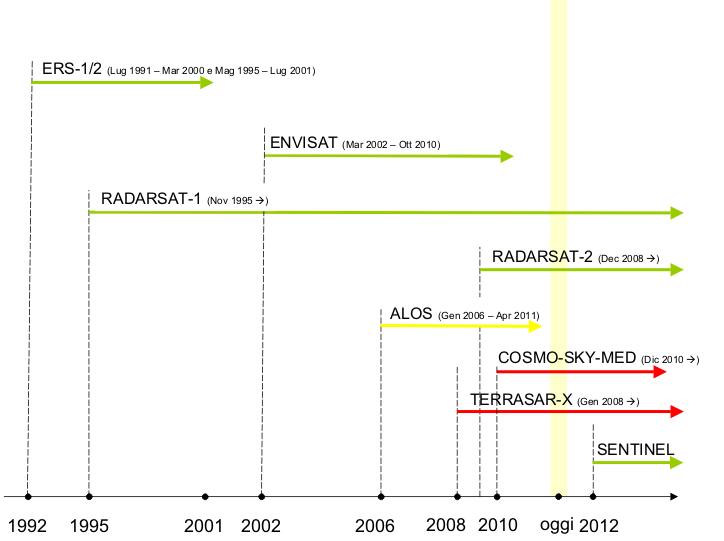
Figure 1 – Timeline SAR missions from 1992
Each of the above mentioned services can be adapted to specific Customer requirements. For more information, kindly contact us by: